
Delphi
Delphi
Delphi is not a harbour town that later got a temple. It is a sanctuary that made the harbours matter. Greeks called the stone in the adyton the omphalos, the navel of the earth. Two eagles, Zeus’s story said, met here. The god who owned the slope was Apollo, who — in the Homeric Hymn — killed the serpent and took the shrine from an older earth cult. The priestess, the Pythia, sat over the cleft and spoke. Cities sent treasure. Generals sent questions.
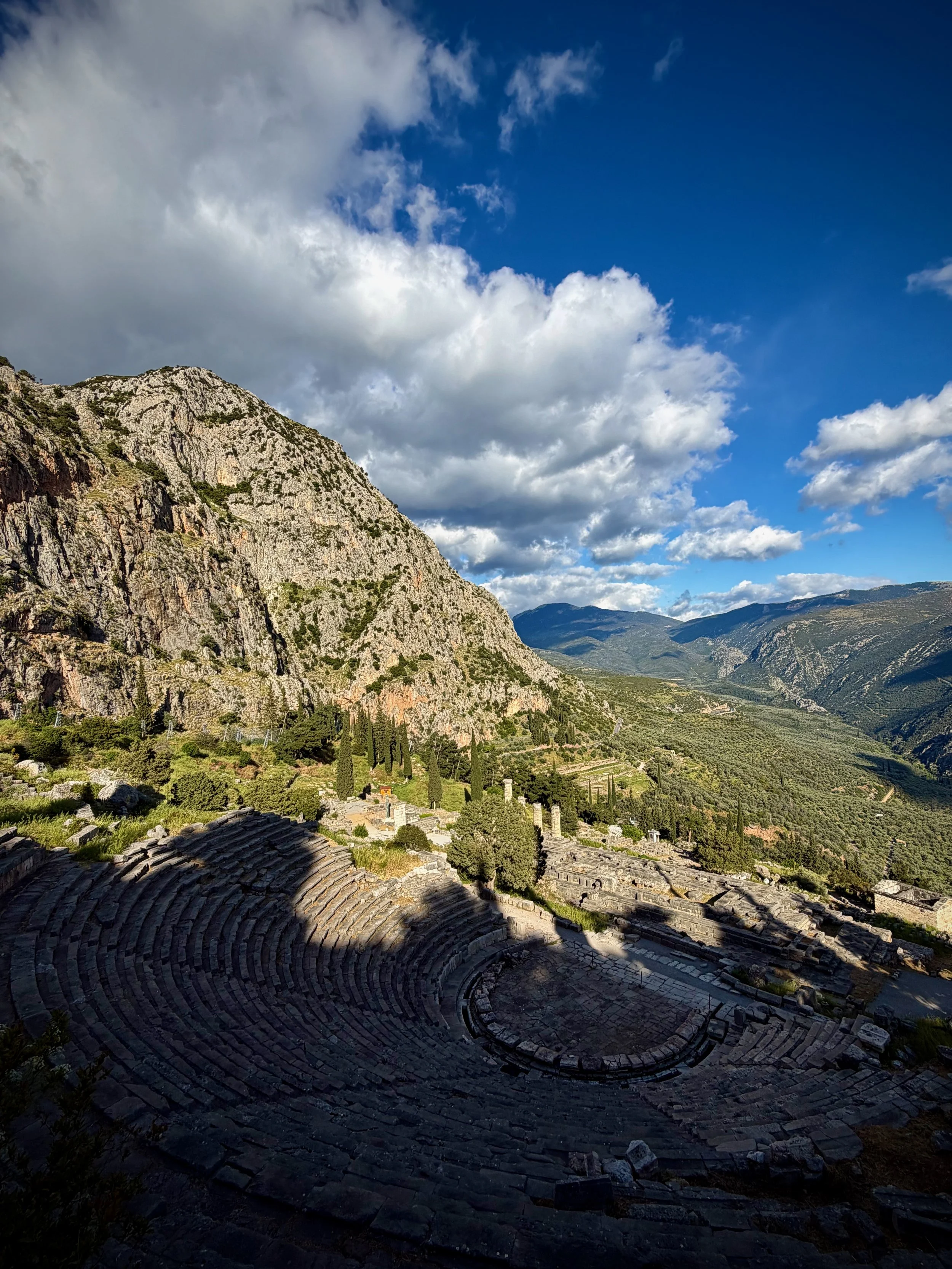
What you walk is the Sacred Way, switchbacking up through treasuries. The Athenian Treasury still stands rebuilt: Athens parked a slice of Marathon and a slice of pride in stone. The Siphnian Treasury was richer and is now mostly in the museum. Above them the Temple of Apollo is a platform and columns, not a complete cella. That is enough. The theatre sits on the temple’s shoulder — a Greek theatre still used for the summer festival. Higher still, the stadium held the Pythian Games, Apollo’s answer to Olympia.
Herodotus is the sailor’s author here. Croesus of Lydia asked if he should attack Persia and was told he would destroy a great empire. He did: his own. Before Salamis the Athenians were told to trust the wooden wall; Themistocles read ships, not the Acropolis fence. After the Persian Wars the Greeks raised the Serpent Column from the spoils of Plataea (the column later went to Constantinople). Delphi is where pan-Hellenic politics wore a religious face.
Alexander came. So did Hellenistic kings and Roman emperors, including Hadrian. Nero lifted statues. By late antiquity the voice had thinned. Christianity shut the oracle. What French excavators stripped out of the village of Kastri from 1892 onward is the site you walk: a mountain street of dedications, not a city grid.
For this guide Delphi is the type-site of the Oracles / Sanctuaries tag and the cleanest Apollo page in the book. It is also the reminder that some of the essential Mediterranean sites are one taxi inland from a working gulf harbour. You do not sail to the Pythia. You sail to Itea or Galaxidi, then you climb.
Site Location
Delphi, Phocis, Greece (south slope of Mount Parnassus)
Coordinates
Sanctuary: 38° 28.95′ N 022° 30.05′ E
Itea port / marina (nearest working quay): 38° 26.0′ N 022° 25.5′ E (approx.)
Galaxidi harbour (preferred yacht stop): 38° 22.6′ N 022° 23.0′ E (approx.)
Site Description
A terraced sanctuary above the modern village. Route: museum (do this first or last) → Sacred Way → treasuries → Temple of Apollo → theatre → stadium if you have the legs. The Castalian Spring is beside the road. Allow three to four hours; the museum is not optional if you care about the bronze Charioteer.
Cruising Access
⚓ Galaxidi — best sheltered harbour on this stretch of the Corinthian Gulf; taxi ~30–40 min to the site
⚓ Itea — closer (~20–25 min) but a commercial/work port
🚶 No walk-off-the-boat access. Parnassus is inland.
⚠ Summer coaches from Athens pack the site mid-morning. Go off the ship early. Winter hours are short. The gulf itself is an easy reach from the Corinth Canal or from the northern Peloponnese; the mountain road is the only hard part.
Nearby Museums / Libraries
Delphi Archaeological Museum — Charioteer of Delphi, Siphnian frieze, omphalos, bronze and ivory. Same ticket complex as the sanctuary.
Practical Tips
Combined site + museum ticket.
Theatre and temple photographs want afternoon side-light; the museum wants your fresh attention.
Combine with a night in Galaxidi, not a dash back to the Canal the same afternoon.
Hosios Loukas is a Byzantine add-on inland if you have a car and a second half-day — separate tag world.
Cruising Guides
Greek Waters Pilot (Heikell) — Corinthian Gulf / Itea / Galaxidi
Imray G12 or Ionian/Corinthian Gulf coverage
Also sail / also see
Galaxidi — the harbour you will actually like
Ancient Corinth / Lechaion — the other end of the gulf and the Canal
Delos — Apollo’s island sanctuary (different sea, same god)
Olympia — the other pan-Hellenic games site (also a taxi from a west-coast gulf)
Delphi
Mycenae
Mycenae
Mycenae sits on a low limestone ridge at the head of the Argive plain, looking toward the gulf a sailor still uses. In the Late Bronze Age this was not a provincial fort. It was the name-site of a civilization: palaces at Mycenae, Tiryns, Pylos, Thebes, and Knossos after the Mycenaean takeover of Crete. Linear B tablets call the wanax, the king. Homer, writing centuries later in the Dark Age, still knew the place as Agamemnon’s seat — the commander who led the ships to Troy.
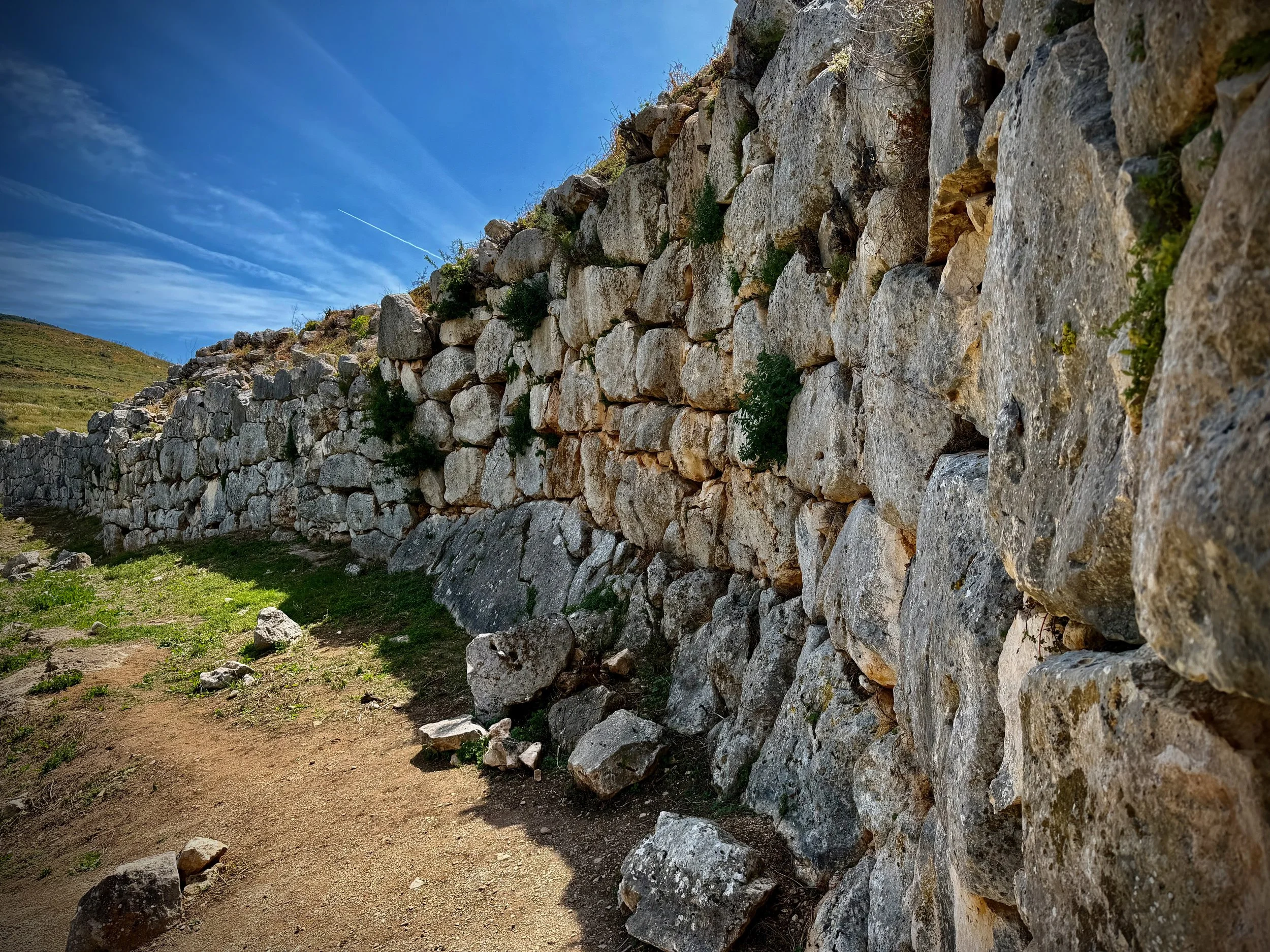
The walls are what the later Greeks called Cyclopean (see photo below): limestone blocks no ordinary crew could have lifted. You enter under the Lion Gate (ca. 1250 BCE), the oldest monumental sculpture in Europe still in situ — two lions, now headless, flanking a column above a single lintel. Just inside is Grave Circle A. In 1876 Heinrich Schliemann dug here looking for Agamemnon and pulled out gold masks, daggers, and cups. The most famous mask is sixteenth-century BCE, three hundred years too early for a historical Trojan War king. Call it what it is: the royal dead of an earlier Mycenaean generation, and the moment modern archaeology decided Homer might have been pointing at a real hill.
The palace on the summit is a megaron plan — hearth, throne room, storerooms — burned in the destructions that ended the palatial world around 1200 BCE. Below the citadel, along the modern road, the Treasury of Atreus (also called the Tomb of Agamemnon) is a tholos: a 35 m dromos, a 120-ton lintel, a corbelled dome 14.5 m across. It was already looted by Roman times. Lord Elgin took the façade columns; pieces now sit in London and Athens. The engineering is the point. No classical temple on this coast is built like that.
Mycenae and Tiryns were inscribed together as UNESCO in 1999. For this guide the pair matters: Tiryns is the seaward citadel, Mycenae the inland throne. A cruiser who only sees Nafplio’s Venetian walls has not yet seen the Bronze Age that named the Argolid.
What you walk is compact — two hours if you are brisk, half a day if you take the museum and the tholos. The gold is not here. Most of Schliemann’s finds are in the National Archaeological Museum in Athens. The on-site museum holds what later digs left in Argolis. That split is worth saying in the entry so nobody expects the mask under the Lion Gate.
Site Location
Mykines, Argolis, Peloponnese, Greece
Coordinates
Citadel (WGS84): 37° 43.85′ N 022° 45.38′ E
Sailor’s door — Nafplio marina / old harbour: 37° 34.0′ N 022° 48.0′ E (approx.)
Nearest sea: ~16 km SSE across the Argive plain
Site Description
A fortified acropolis above the village of Mykines. Circuit: Lion Gate → Grave Circle A → palace plateau → views over the plain toward the gulf → walk back down the road to the Treasury of Atreus (separate ticketed entrance, same site ticket). Not visible from the water.
Cruising Access
⚓ Nafplio (Náfplio) — the working base: town quay, marina, and yards on the Argolic Gulf
⚓ Tolo / Drepano — alternative gulf stops, still a taxi to Mycenae
🚶 Nafplio → Mycenae: ~20–25 min by taxi / rental car (~24 km). No dinghy, no bus-from-the-beach fantasy.
⚠ This is a car site. It sits inside your 20–25 km coastal rule by straight-line distance to the gulf, not by walking off the bow.
Nearby Museums / Libraries
Archaeological Museum of Mycenae (on site; included with the ticket)
National Archaeological Museum, Athens — Grave Circle A gold, including the “Mask of Agamemnon”
Nafplio Archaeological Museum — useful the same afternoon if you still have legs
Practical Tips
One ticket covers citadel, Treasury of Atreus, and on-site museum.
Do the tholos on the way in or out; it is down the road, not inside the walls.
Summer: open early, bring water; the plateau is bare stone.
Pair with Tiryns the same day — Tiryns is on the road back toward Nafplio and much closer to the water.
If you only have one Argolid ruin day from the boat, Mycenae + Tiryns beats a rushed Epidauros add-on.
Cruising Guides
Greek Waters Pilot (Heikell) — Nafplio / Argolic Gulf chapter (Mycenae is the inland excursion, not a harbour plan)
Imray G12 / Argolic Gulf
Also sail / also see
Tiryns — UNESCO twin; the coastal citadel
Nafplio — Venetian fortress town; your berth
Ancient Corinth — north, same Palamidi–Isthmus axis
Epidauros — theater; separate day if you can
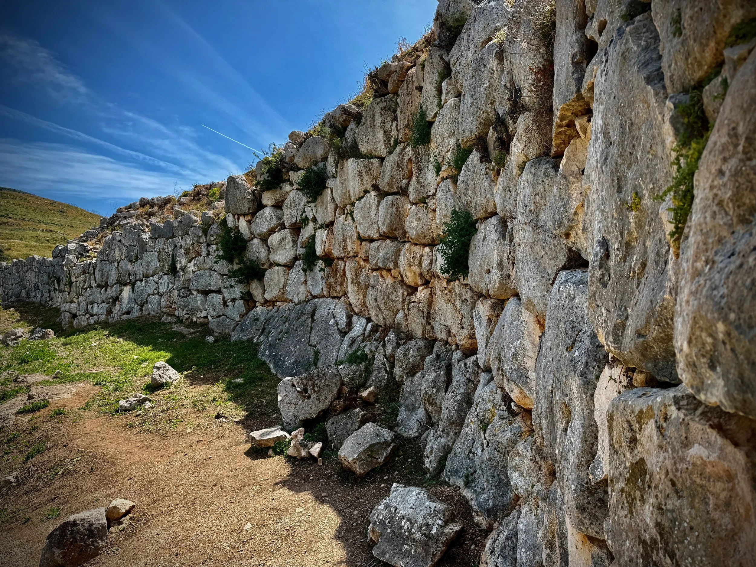
The Cyclopean Wall of Mycenae
Monemvasia
Monemvasia
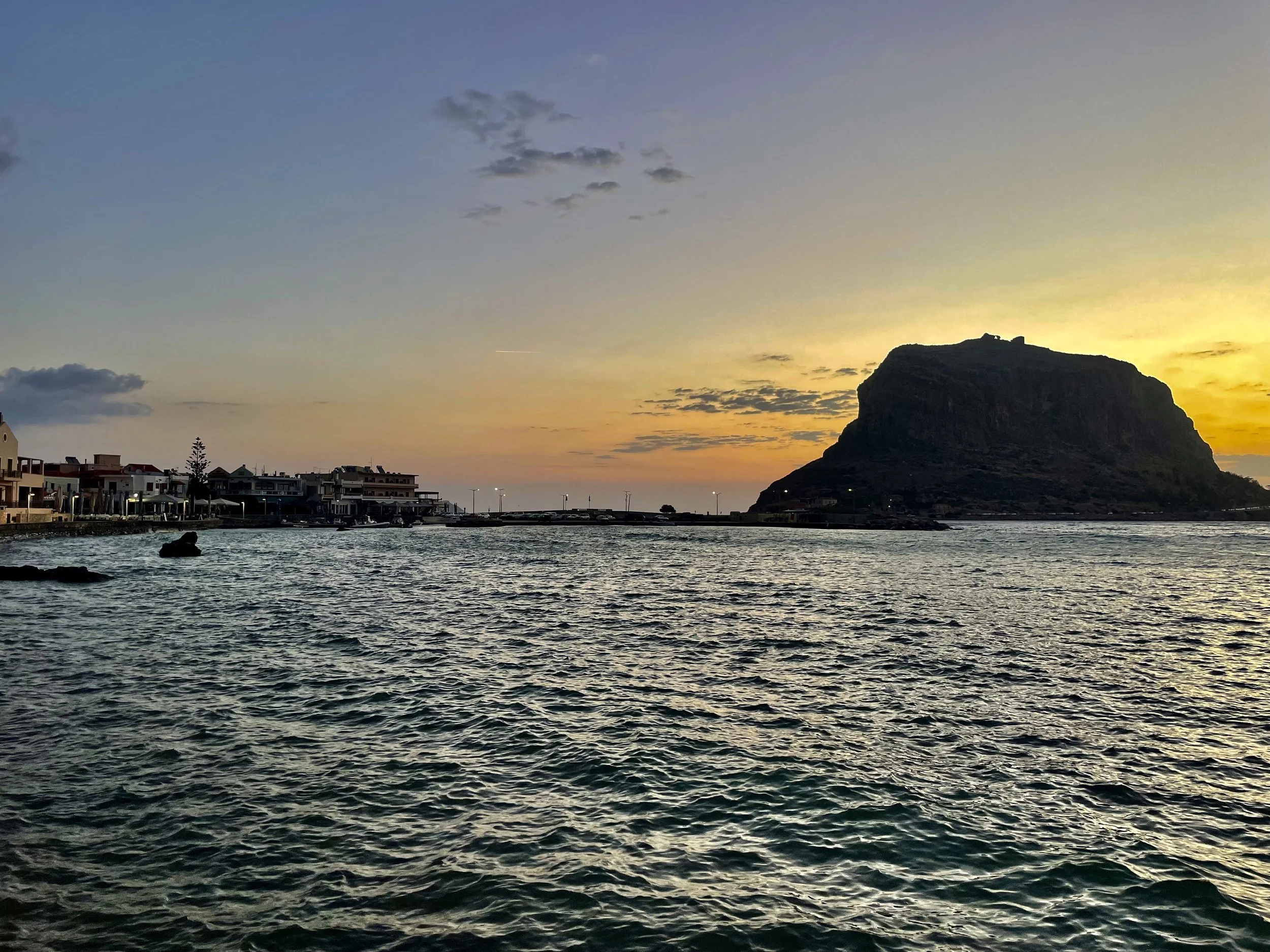
Monemvasia is not a classical polis sitting on a marble street. It is what the late antique Aegean did when the old cities failed. In 375 CE an earthquake tore this slab of rock from the Laconian shore. Two centuries later, in 582 or 583, people from inland Lacedaemon climbed it to escape Slavic and Avar raids that were emptying the Peloponnese. The Chronicle of Monemvasia remembers that flight. The name is literal: mone emvasia — one entrance. You still walk in through a single vaulted gate in a high wall.
From the tenth century the rock was a Byzantine naval and commercial station on the route between Constantinople and the west. Arabs and Normans failed to take it. After 1204 the Franks of the Principality of Achaea finally starved it out (1248–49); the Byzantines of the Despotate of the Morea took it back in 1262. Churches multiplied in the lower town. On the plateau, Agia Sophia — a compact inscribed-cross church in the Constantinopolitan manner — looks straight down the cliff to the sea.
The port shipped the sweet wine the west called Malmsey or Malvasia, a corruption of the place-name. Corsairs used the same cliffs. After Constantinople fell in 1453, Monemvasia was among the last Byzantine holdings in the Morea. Thomas Palaiologos could not hold it; it passed to the Pope, then in 1463 to Venice. Venetian and Ottoman flags swapped twice (Venice 1463–1540 and 1690–1715; Ottomans 1540–1690 and 1715–1821). It was never stormed. Blockade and treaty did the work. In July 1821 it was the first fortress in the Peloponnese to raise the Greek flag.
What you walk today is that stack of centuries in one street: Byzantine masonry, Venetian doorframes, an Ottoman mosque converted back to a church, houses rebuilt after mid-century abandonment. The upper town is a ruin on a windy plateau. The lower town is lived-in. For a sailor this is the rare site that is the harbour view. The rock is the waypoint. Cape Maleas, fifteen miles south, is why Homer belongs on the tag list — not because the poet named this town, but because this is the last sheltered wall before the cape that sent Odysseus wandering.
Site Location
Monemvasia, Laconia, Peloponnese, Greece
Mainland village: Gefyra (Yefira), at the west end of the causeway
Coordinates
Harbour / marina entrance (Heikell, WGS84): 36° 41.09′ N 023° 02.39′ E
Rock / lower-town gate: 36° 41.16′ N 023° 03.20′ E
Alternative anchorage, Palaia Monemvasia / Ormos Paleó (north, near Epidauros Limera): 36° 43.8′ N 023° 02.1′ E
Site Description
From the approach the rock reads as an island citadel — 1 km long, 300 m wide, plateau ~100 m up. A short causeway and bridge join it to Gefyra. Lower town is a single east–west street behind the sea wall. Upper town is a steep, paved climb to the fortress and Agia Sophia. Allow half a day for the rock, a full day if you add Epidauros Limera to the north.
Cruising Access
⚓ Gefyra harbour / small marina, immediately west of the causeway — walk or short taxi to the gate
⚓ Ferry mole north of the causeway — possible alongside; awkward in meltemi
⚓ Palaia Monemvasia bay ~3 nm north — quieter, dinghy or walk toward Epidauros Limera
🚶 Causeway to the single gate is 400 m from the harbour village
⚠ Meltemi puts swell onto the north mole. Night katabatics off the hills can gust 30–40 kn. Holding in places is rock and weed — test the set. Harbour works have been ongoing; depths and berths change. Water on the quay can be brackish.
Nearby Museums / Libraries
Monemvasia Archaeological Collection (lower town) — icons, sculpture, and finds from the rock and from Epidauros Limera.
Practical Tips
Enter the rock on foot; cars stop in Gefyra.
Upper town is a real climb and exposed; go early or late.
Agia Sophia is the photograph; the gate and sea wall are the sailor’s shot.
Eat and provision in Gefyra; the lower town is prettier and more expensive.
If bound south, treat Cape Maleas as its own passage plan — not a casual afternoon hop.
Cruising Guides
Greek Waters Pilot (Heikell), 14th ed. — Monemvasia plan ~p. 248 (check your supplement; the harbour has been extended)
Imray G36 / eastern Peloponnese sheets
Also sail
[Epidauros Limera] — classical city a few miles north; the ancient harbour of this coast
Cape Maleas — Odyssey 9; round it only on a settled forecast
Kythira / Elafonisos — the next rooms south after the cape
Mystras — inland Byzantine pair to this rock (car from Gefyra; not a dinghy site)